


Layers and Groups Tab #
Fare riferimento alla seguente guida per tutte le impostazionihttps://qgis2web.github.io/qgis2web/#LayersandGroups
Popup Avanzato #
qgis2o.gis integra un popup che evidenzia la funzionalità selezionata e consente di sfogliare le funzionalità sovrapposte.
Questo popup avanzato supporta le varie opzioni sopra descritte.
| Prima feature | Seconda feature |
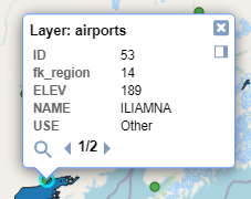 | 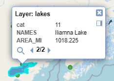 |
Per impostazione predefinita #
- la scheda mostra l’elenco dei layer presenti nel progetto QGIS, ma il controllo dell’esportazione sarà presente solo nei layer QGIS attivati prima dell’avvio del plugin
- i layer non hanno il check “Visibile”, quindi all’avvio del progetto esportato non saranno immediatamente visibili sulla mappa
- I popup hanno sempre il segno di spunta attivo quindi sarà possibile interrogare i layer nel progetto esportato (per nascondere i campi dal popup di interrogazione imposta Nascosto come spiegato qui)
- I popup hanno sempre il segno di spunta attivo quindi sarà possibile interrogare i layer nel progetto esportato (per nascondere i campi dal popup di interrogazione imposta Nascosto come spiegato
Scheda Appareance #
Match project CRS #
Crea la mappa web nella stessa proiezione del progetto QGIS, altrimenti la mappa web viene proiettata in EPSG:3857
Show popups on hover #
Mostra i popup quando il mouse passa sopra le funzionalità
Highlight on hover #
Evidenzia le funzionalità al passaggio del mouse
Template #
Viene fornito un modello predefinito, puoi aggiungerne altri come preferisci.
Extent #
Livello di zoom predefinito all’avvio del progetto esportato. L’estensione della tela corrisponde all’attuale QGIS.
Restrict to extent #
Impedisce la panoramica o lo zoom oltre l’estensione selezionata e riduce la dimensione del progetto esportato non includendo geometrie esterne all’estensione selezionata.
Max zoom level #
Quanto verrà ingrandita la mappa web
Min zoom level #
Di quanto verrà rimpicciolita la mappa web
Export Tab #
Fare riferimento alla seguente guida per tutte le impostazioni https://qgis2web.github.io/qgis2web/#Export